
Decoding Guide
Precipitable Water Chart
Description:
Precipitable water is the amount of liquid precipitation that would result if all the water vapor in a column of air was condensed. The precipitable water value is an indicator of the amount of moisture in the air between the surface and 500mb (18,000ft). This chart consists of lines of constant precipitable water amounts(isopleths), along with values taken from observations at individual stations.Issuance:
0000 and 1200 UTCData Sources:
Surface and upper air observations, computer modelsDepiction:
Lines of constant precipitable water are plotted and labeled in white. These lines are drawn for every 0.25 inches of water.Individual observations are depicted in blue. At each station, precipitable water values to the nearest hundredth of an inch are plotted above a symbol and the percent of normal value for the month below the symbol. The percent of normal value is the amount of precipitable water actually present compared to what is normally expected.
Example:
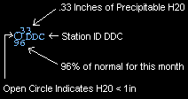
A circle (< 1 in) or shaded circle (>1 in) is usually used to indicate the station location, however, some symbols are used to indicate missing data.
Symbol interpretation:
| Precipitable Water less than 1 in | |
| Precipitable Water greater than or equal to 1 in | |
| All significant observations missing | |
| Some mandatory observations missing | |
| Some mandatory and significant observations missing |